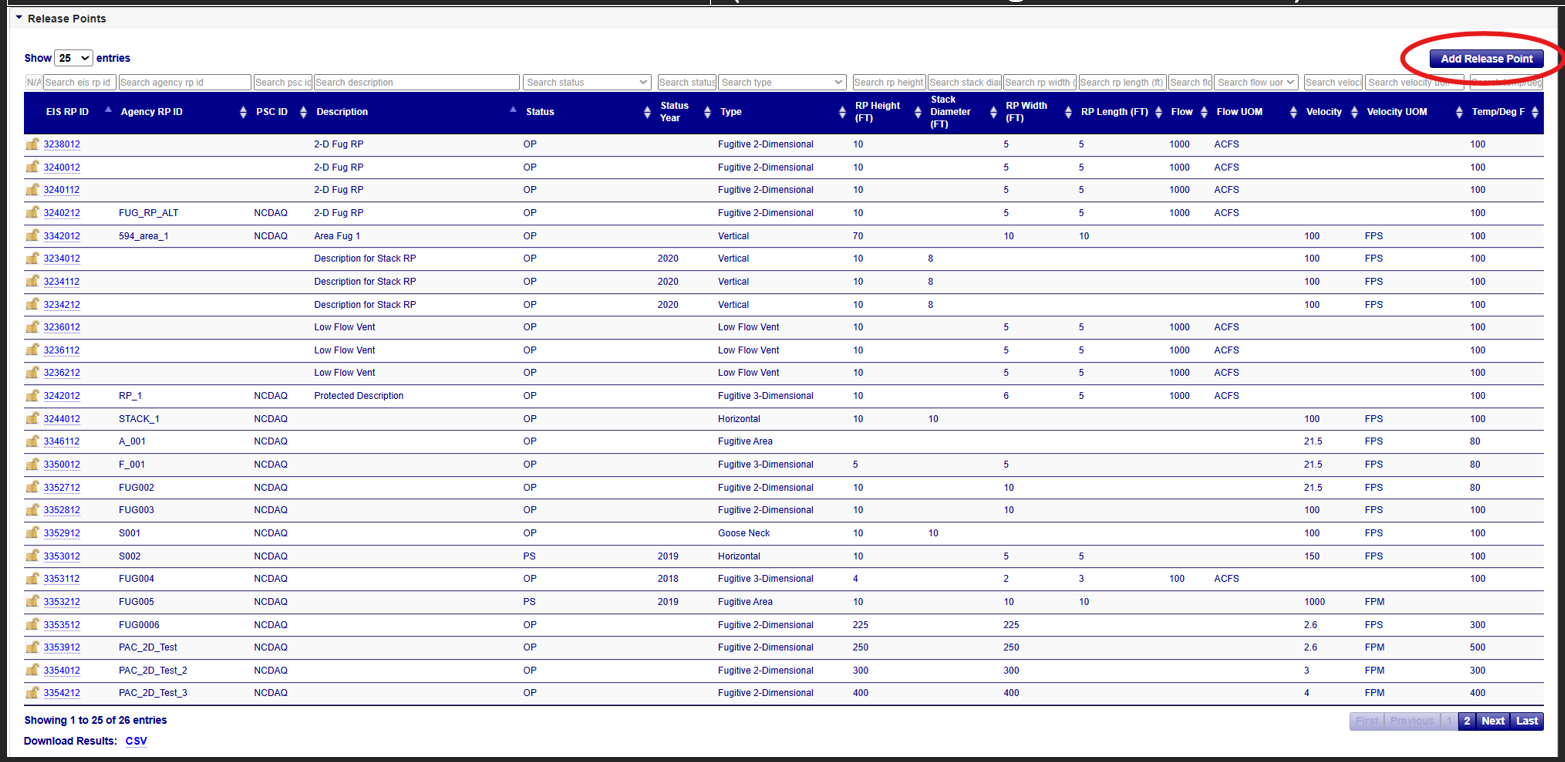
Release Points
You may view a full list of all Release Points associated with a facility from the Release Points accordion. The Release Point list includes all Fugitive and Stack release points associated with a single facility site. This section describes the process for viewing, adding, editing, or deleting Fugitive and Stack Release Points.
Release Points
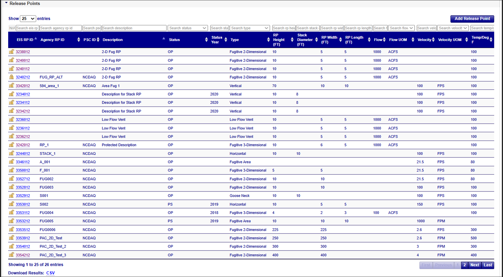
The data table within the release point accordion provides a listing of all types of release points at the facility. You may further select individual records by clicking on the EIS Release Point (RP) Identifier to see additional information about the Release Points based on the Release Point type. The accordion table displays the following fields:
| Column Name | Description |
|---|---|
| EIS Release Point (RP) ID | EIS Identifier for the release point as defined by the EIS System. Clicking on this ID will display more details about the record. |
| Agency Release Point (RP) ID | An identifier by which an element is referred to by the responsible agency system. |
| PSC (Program System Code) ID | Code that represents the information management system, responsible for the data in a linked or interrelated information management system. |
| Description | Text description of release point. |
| Status | Code that identifies the operating status of the release point. |
| Status Year | Operating Status Year for the release point. |
| Type | The type of release point. |
| RP Height (FT) | The height of the release point from the ground (in feet). |
| Stack Diameter (FT) | The internal diameter of the stack (measured in feet) at the release height (in feet). |
| Release Point Width (FT) | The width of the release in the East-West direction, as if the angle is zero degrees (in feet). |
| Release Point Length (FT) | The length (measured in feet) of the release in the North-South direction, as if the angle is zero degrees (in feet). |
| Flow | The Stack gas flow rate (in actual cubic feet per second (ACFS)). |
| Flow Unit of Measure (UOM) | The unit of measure for the exit gas flow rate value. |
| Velocity | The velocity of an exit gas stream. |
| Velocity Unit of Measure (UOM) | The unit of measure for the velocity of an exit gas stream value. |
| Temp/Deg F | The temperature of an exit gas stream (measured in degrees Fahrenheit). |
Viewing Release Points
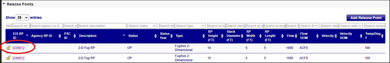
After expanding the Release Points accordion menu within the Facility Site page, clicking on the EIS RP ID within the table will take you to the details of that Release Point on the View Release Point page. The view will vary based on the Release Point type. If the Release Point, or specific fields of the Release Point, are protected/locked, it will display a closed lock icon to the left of the EIS RP ID in the accordion table. To see if it is the entire Release Point or which specific field, click on the RP ID to navigate to the View Release Point page. The lock icon will appear next to the field that is protected/locked. Please contact an EPA Inventory Developer if you need assistance with any protected data fields or facility components.
Fugitive Release Points
Clicking on the EIS Release Points ID of a Fugitive Release Point within the table will take you to the details of that Fugitive Release Point on the View Release Points page. Fugitive Release Point types include Fugitive Area, Fugitive 2-D, or Fugitive 3-D.
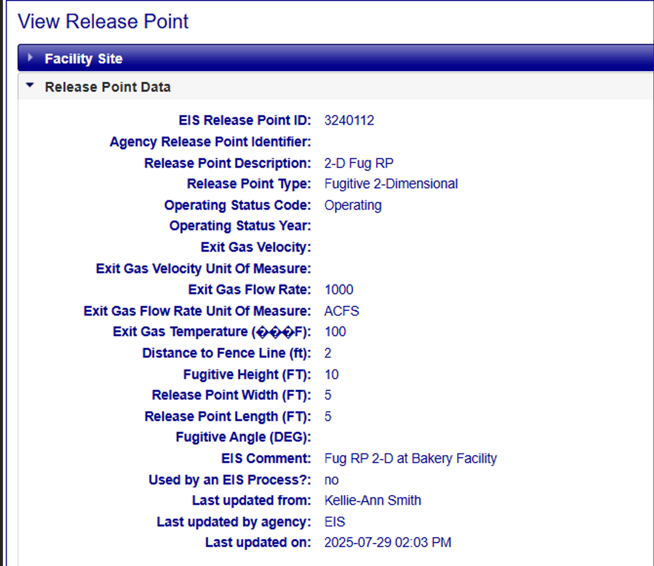
The View Release Point (Fugitive) page displays the following information:
| Column Name | Description |
|---|---|
| EIS Release Point ID | EIS Identifier for the release point as defined by the EIS System. Clicking on this ID will display more details about the record. |
| Agency Release Point ID and Program System Code | An identifier by which an element is referred to by the responsible agency system. |
| Program System Code (Combined with the Agency Release Points ID field) | Code that represents the information management system, responsible for the data in a linked or interrelated information management system. |
| Release Points Description | Text description of Release Points. |
| Release Points Type | The type of release point. |
| Operating Status Code | Code that identifies the operating status of the release point. |
| Operating Status Year | Operating Status Year of the Release Points. |
| Exit Gas Velocity* | The velocity of the exit gas stream. |
| Exit Gas Velocity Unit of Measure (UOM) | The code that identifies the lookup value to be reported. |
| Exit Gas Flow Rate* | The unit of measure for the stack gas flow rate value. |
| Exit Gas Flow Rate Unit of Measure (UOM) | The unit of measure for the velocity of an exit gas stream value. |
| Exit Gas Temperature (Degree F)* | The temperature of the exit gas stream, measured in degrees Fahrenheit. |
| Distance to Fence Line (ft) | The measure of the horizontal distance to the nearest fence line of a property within which the release point is located. |
| Fugitive Height (FT)* | The Fugitive release height above terrain of Fugitive emissions (in feet). |
| Release Points Width (FT)* | The width of the release in the East-West direction, as if the angle is zero degrees (in feet). |
| Release Points Length (FT)* | The length (measured in feet) of the release in the North-South direction, as if the angle is zero degrees (in feet). |
| Fugitive Angle (DEG)* | The orientation angle for the area in degrees from North, measured positive in the clockwise direction from the western-most point. |
| EIS Comments | Any comments regarding the reported data. |
| Used by an EIS Process? | Indicates that the Release Point is utilized in an EIS process. |
| Last Updated From | The person who made the last change. |
| Last Updated by Agency | The agency to which the “Last Updated By” is associated. |
| Last Updated On | Date the information was last updated. |
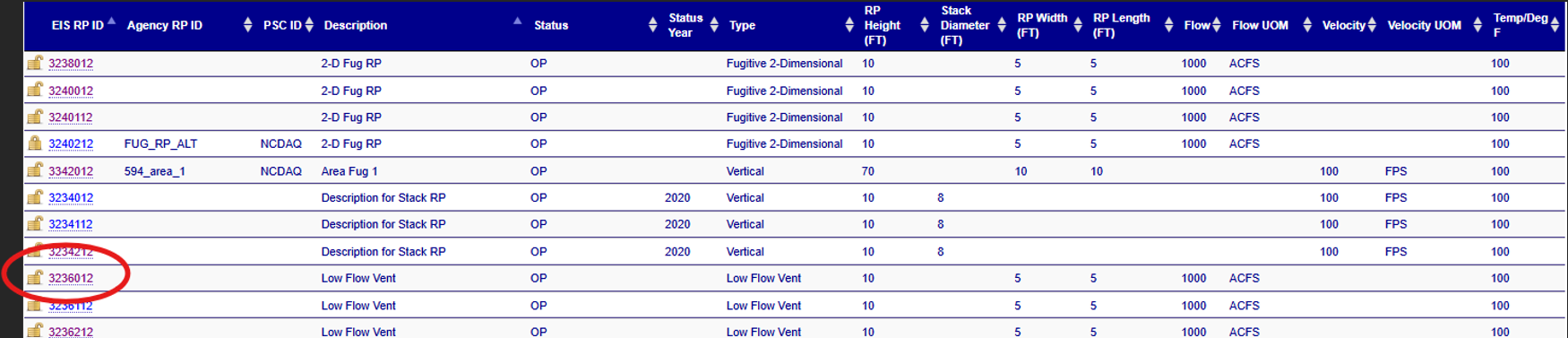
Stack Release Points
Clicking on the EIS Release Points ID of a Stack Release Point within the table will take you to the details of that Stack Release Point on the View Release Points page. Stack Release Point types include Downward-facing vent, Goose Neck, Horizontal, Low Flow Vent, Vertical, and Vertical with Rain.
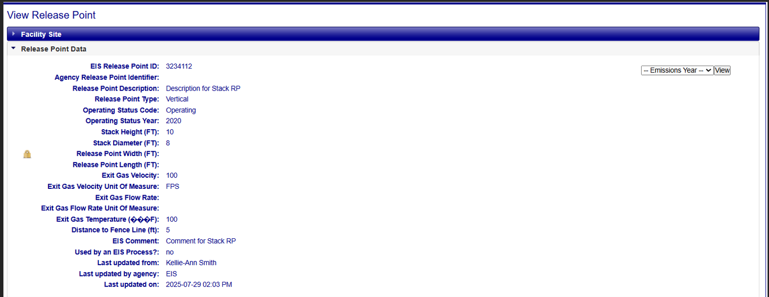
The Stack Release Point view displays the following information:
| Column Name | Description |
|---|---|
| EIS Release Point ID | EIS Identifier for the release point as defined by the EIS System. Clicking on this ID will display more details about the record. |
| Agency Release Point ID | An identifier by which an element is referred to by the responsible agency system. |
| Program System Code (Combined with the Agency Release Points ID field) | Code that represents the information management system, responsible for the data in a linked or interrelated information management system. |
| Release Points Description | Text description of Release Points. |
| Release Points Type | The type of release point. |
| Operating Status Code | Code that identifies the operating status of the release point. |
| Operating Status Year | Operating Status Year of the Release Points. |
| Stack Height (FT)* | The height of the Stack from the ground, measured in feet. |
| Stack Diameter (FT) * | The diameter of a Stack at the release height, measured in feet. |
| Fugitive Height (FT)* | The Fugitive release height above terrain of Fugitive emissions (in feet). |
| Release Points Width (FT)* | The width of the release in the East-West direction, as if the angle is zero degrees (in feet). |
| Release Points Length (FT)* | The length (measured in feet) of the release in the North-South direction, as if the angle is zero degrees (in feet). |
| Exit Gas Velocity* | The velocity of the exit gas stream. |
| Exit Gas Velocity Unit of Measure (UOM) | The code that identifies the lookup value to be reported. |
| Exit Gas Flow Rate* | The unit of measure for the stack gas flow rate value. |
| Exit Gas Flow Rate Unit of Measure (UOM) | The unit of measure for the velocity of an exit gas stream value. |
| Exit Gas Temperature (Degree F)* | The temperature of the exit gas stream, measured in degrees Fahrenheit. |
| Distance to Fence Line (ft) | The measure of the horizontal distance to the nearest fence line of a property within which the release point is located. |
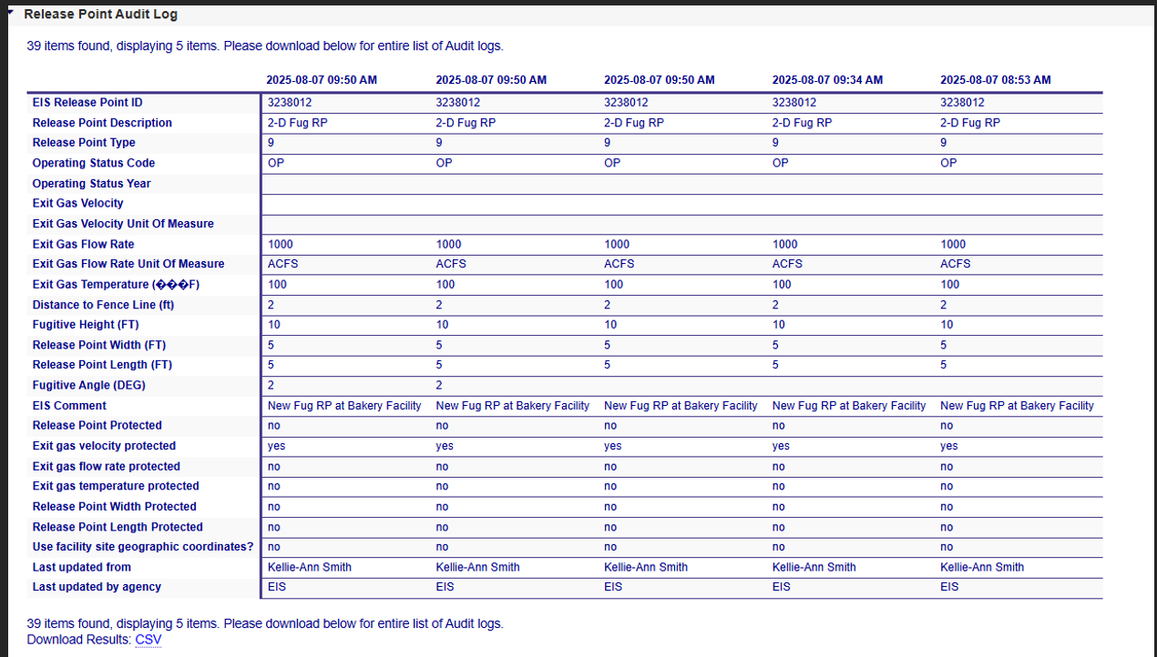
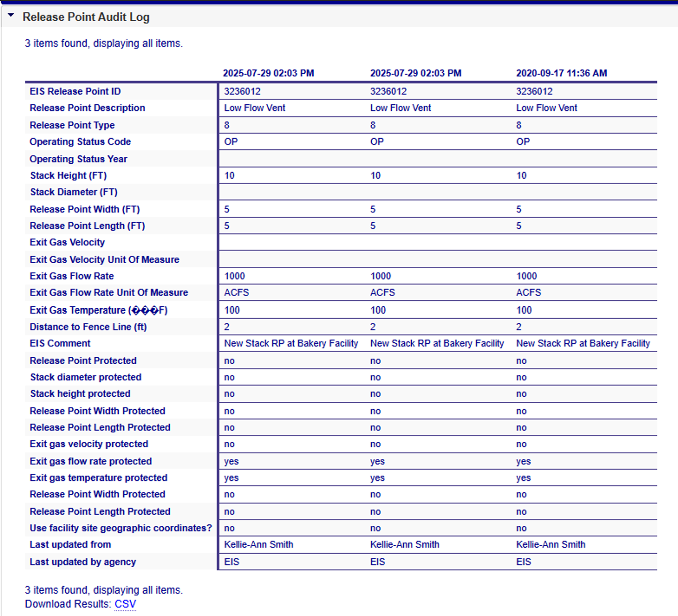
Release Point Audit Log
Provides information about changes that have occurred to the information about the Release Points associated with a facility site. It provides time-stamped values of data at the facility site, indicating who made the changes and which organization that person is associated. Please see the Release Point column for descriptions of the fields presented if needed.
Fugitive Release Point
Stack Release Point
Adding Release Point Records
If you have been authorized to update information for your agency, you will see an Add link in upper-right corner of the Release Point accordion.
Clicking on this link will open a blank form that will allow you to create a new Release Point for the facility record by populating the fields. The view changes based on the Release Point type selected.
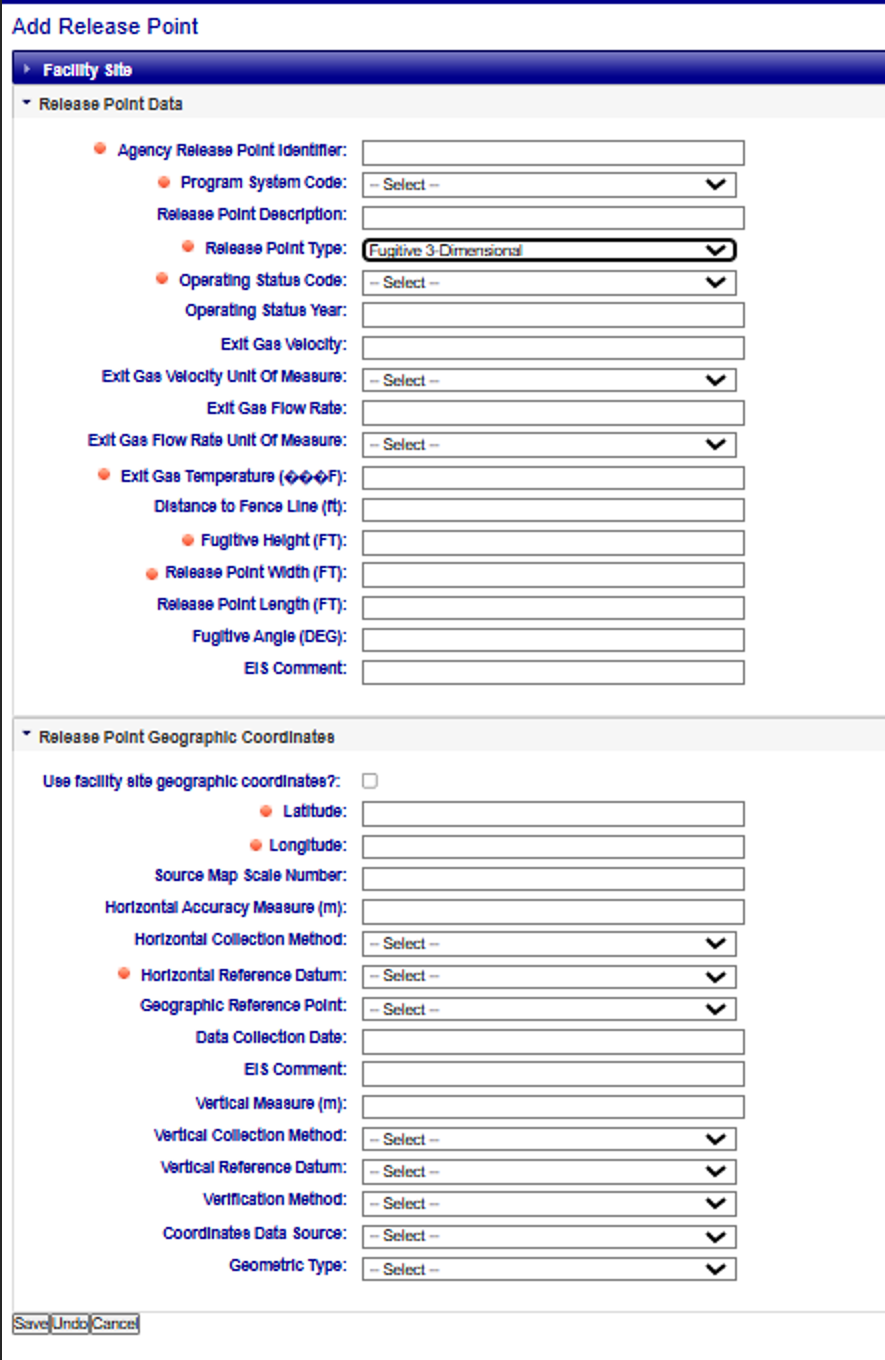
Adding Fugitive Release Point Records
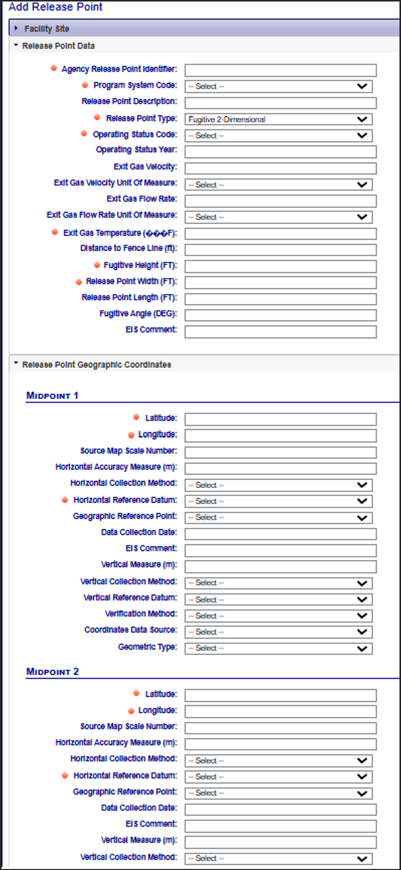
Selecting Fugitive 2D or Fugitive 3D as the Release Point Type will display the following fields, allowing you to create a new Fugitive Release Point for the facility record by populating those fields. Please note, Fugitive Area is no longer a selectable Release Point type, but is still viewable.
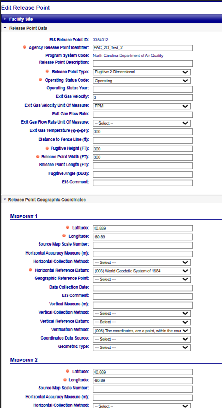
When creating a new Fugitive 2D Release Point, it will require Geographic Coordinate values for Midpoint 1 and Midpoint 2. As a reminder, unique latitude and longitude coordinates are required for each midpoint. For more information on midpoints, refer to the Release Points Geographic Coordinates page of the user guide.
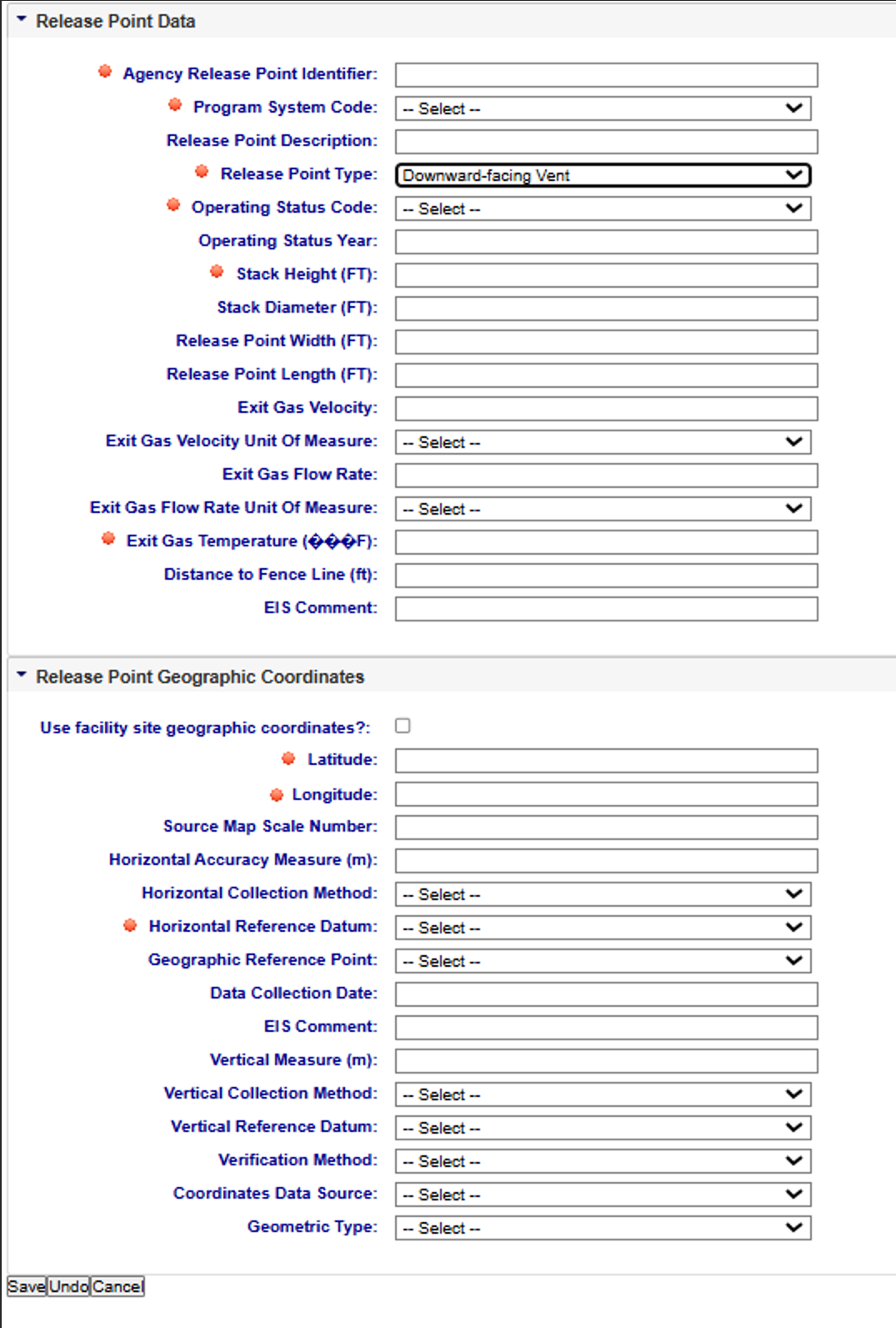
Adding Stack Release Point Records
Selecting Downward-facing vent, Goose Neck, Horizontal, Low Flow Vent, Vertical, and Vertical with
Rain Cap will display the following fields, allowing you to create a new Stack Release Point for the
facility record by populating those fields. As a reminder, Stack Release Points will have one of the following:
1) Report Stack Diameter AND Stack Diameter Unit of Measure AND do not report Release Point Length
AND do not report Release Point Width.
OR
2) Report Release Point Length AND Release Point Width AND do not report Stack Diameter.
Editing Release Point Records
If you have been authorized to update information for your agency and the facility inventory window is open, you will see additional links available at the top right corner of the View Release Point page:
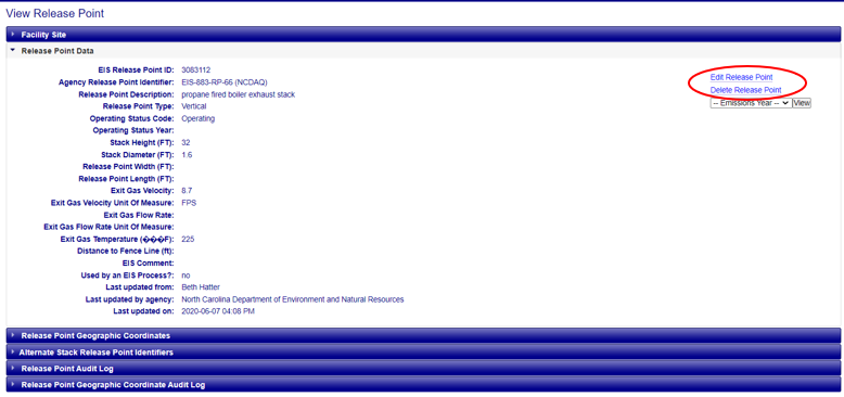
Clicking on the “Edit Release Point” link will open a form that will allow you to make changes to the information. Once all necessary fields have been populated, click on the “Save” button at the bottom of the form. Note that the fields have a red “starburst” indicator next to them, indicating that they are required fields. You will not be able to successfully save the information to the data base without values populated in these fields. EIS will evaluate the information provided. If there are any issues, errors will be displayed at the top of the form. If the Release Point, or specific fields of the Release Point, are protected/locked, you will not be able to edit it. Please contact an EPA Inventory Developer if you need assistance with any protected data fields or facility components.
Editing Fugitive Release Point Records
Fugitive Area is no longer a selectable Release Point type but is still viewable. You can edit a Fugitive Area to Fugitive 3D or 2D. If you change to Fugitive 2D from any other Release Point type, you will need to edit the Release Point Geographic Coordinates to include midpoint 1 and midpoint 2. As a reminder, unique latitude and longitude coordinates are required for each midpoint. This information can be found on the Release Points Geographic Coordinates page of the user guide.
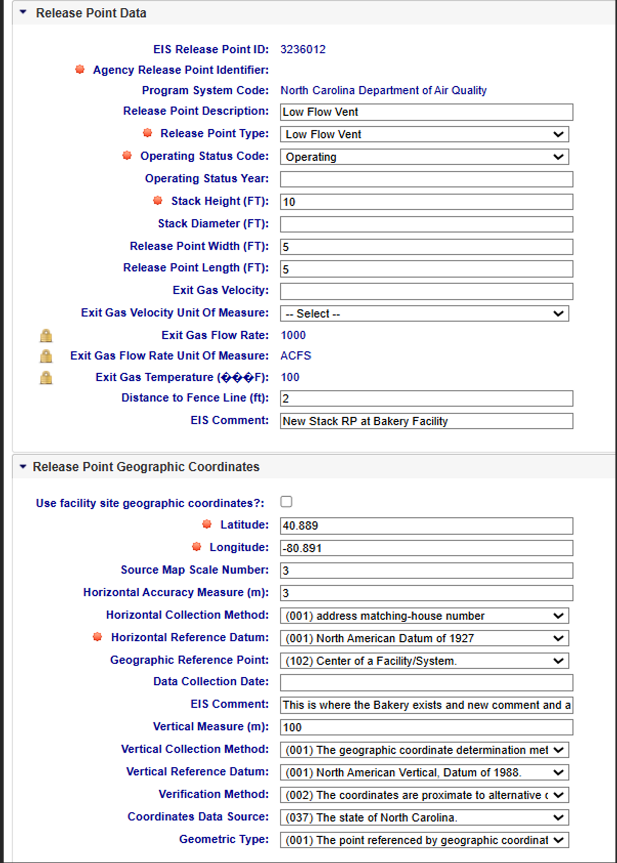
Editing Stack Release Point Records
As a reminder, Stack Release Points will have 1 of the following scenarios for populating the data
fields associated with a Stack Release Point:
1) Report Stack Diameter AND Stack Diameter Unit of Measure AND do not report Release Point Length
AND do not report Release Point Width.
OR
2) Report Release Point Length AND Release Point Width AND do not report Stack Diameter.
Clicking on the “Undo” button will clear the form of all entries and leave you on the “Edit Release Point” page. Clicking on the “Cancel” button will not save any of the information that you have filled out, and you will be taken back to the Facility Site page.
Deleting Release Point Records
Clicking on the “Delete Release Point” link from the View Release Point page will allow you to delete a Release Point associated with the facility. You will receive a confirmation message asking if you’re sure you want to delete. Clicking OK will delete the Release Point from the facility site and return you to the Facility Site page. Clicking Cancel will not delete the Release Point, and you will remain on the View Release Point page. This applies to both Fugitive and Stack Release Points. If the Release Point, or specific fields of the Release Point, are protected/locked, you will not be able to edit it. Please contact an EPA Inventory Developer if you need assistance with any protected data fields or facility components.