Facility Inventory and Point Emissions
Introduction
The “View / Add / Edit" Facility Inventory and Point Emissions menu item from the EIS Gateway provides the functionality for you to view a list of facility sites and their details. You may view a full list of facility sites available to you (based on your user type) or select one site and view the detailed information for that site. This section describes the process for viewing a full list of facility sites or for viewing the detailed information for a single facility site.
Facility Inventory
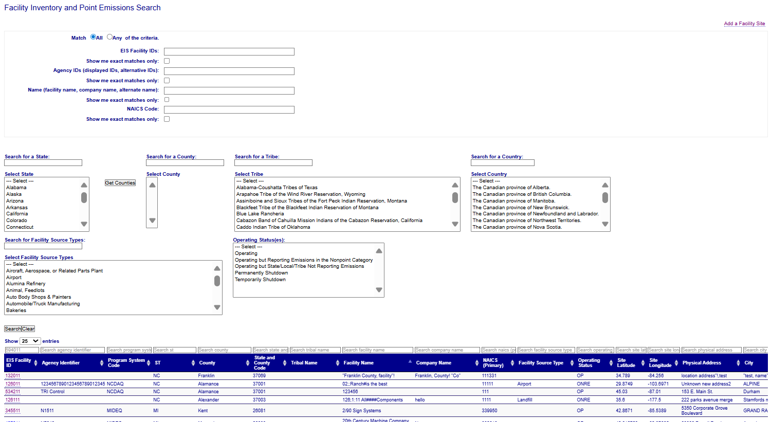
Filtering the List of Facilities
For State/Local/ and Tribal users, a list of all facilities for their agency (and any other agencies to which they have been granted access) are displayed. This list may be further refined by filtering by specific identifiers, facility name, primary NAICS code, by county, by Facility Source Type, and/or by operating status code.
Viewing Facility Details
The resulting list of facility sites will appear below the Search button. The first 25 facility sites will appear on the screen, and you will be able to select another page to display the next 25 facility sites. The double arrows next to each column heading allow you to sort each column. Click on the column heading once and the list will be sorted in ascending order. Click the column heading a second time and the list will be sorted in descending order. At the bottom of the search results is a link that allows you to export the list of facility sites in CSV format.
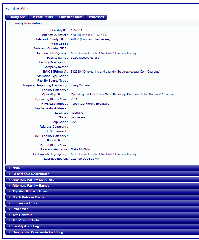
Clicking on the EIS Facility Identifier will take you to the details of that facility. You can “drill-down” to see all levels of information pertaining to the facility site by clicking on the subsequent accordion menus.
Facility summaries of emissions collected at this facility for a given inventory year are available. Choose a year from the “—Emissions Year –” drop-down list on the right side of the screen. You will be presented with the facility summaries for any available data sets for the selected year. The following data sets are considered “available”:
- State/Local/Tribal Data Sets
- Any EPA data dets that have been deemed “Publicly Available”
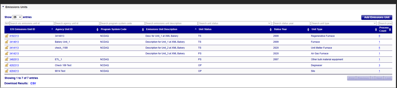
The main portion of the screen contains details about the given facility. There are several blue “accordion” bars below the main information screen. These are additional tables related to the facility that may be expanded by clicking on the accordion bar. These accordions generally contain multiple rows of related information about the facility. For example, a facility may have several emissions units defined at the facility. Clicking on the “Emissions Units” accordion will display basic information about all the defined units at the facility. Clicking on the accordion bar a second time will collapse the accordion bar back its original state.
Facility Site Columns
The Facility Site screen contains the following columns
| Column Name | Description |
|---|---|
| EIS Facility ID | EIS Identifier for the facility as defined by the EIS System |
| Agency Identifier | Responsible Agency Identifier for the facility |
| State and County FIPS | Federal Information Processing Standards code defining the county (or county equivalent) location of the facility |
| Tribal Code | Bureau of Indian Affairs code defining the tribal organization associated with the identifier |
| State and Country FIPS | Federal Information Processing Standards code defining the country of the facility |
| Responsible Agency | The Agency Organization responsible for the information provided about the facility. This is the agency authorized to make changes to the facility. |
| Facility Name | Name of the facility |
| Facility Description | Description of the facility |
| Company Name | Name of the organization. |
| NAICS (Primary) | Code defining the primary NAICS designation for the facility |
| Affiliation Type Code | Identifies the function that an organization or individual serves, or the relationship between an individual or organization and the facility site. |
| Facility Source Type | Code designating the facility's general category (Airport, landfill, etc.) |
| Required Reporting Frequency | Defines the expected frequency for which the facility must report. |
| Facility Category | The code that represents the Clean Air Act Stationary Source designation |
| Operating Status | Code defining the operating status of the facility |
| Operating Status Year | The first year in the which the provided facility status code applies |
| Physical Address | The physical location of a facility site or organization. |
| Supplemental Address | The text that provides additional info about a place, including a building name with its secondary unit and number, an industrial park name, an installation name, or descriptive text where no formal address is available. |
| Locality | The name of the city, town, village, or other locality. |
| State | The alphabetic codes that represent the name of the principal administrative subdivision of the United States, Canada, or Mexico. |
| Zip Code | The code that represents a U.S. ZIP code or International postal code. |
| Address Comment | Any comments regarding the address information. |
| EIS Comment | Any additional comments about the facility |
| HAP Facility Category | Code designating the Hazardous Air Pollutant categorization of the site. |
| Permit Status | The operation status of a permit that applies to a facility |
| Permit Status Year | The beginning year of a permit that applies to a facility |
| Last updated from | Identifies the last person to make changes to the information |
| Last updated by agency | Identifies the organization of the person who made the most recent information change |
| Last updated on | Identifies when the last changes to the information were made |
Facility Site Accordions
The Facility Site screen has the following accordions
| Column Name | Description |
|---|---|
| NAICS Type | The type of NAICS process (Secondary or Tertiary) being represented. |
| NAICS Code | A North American Industry Classification System (NAICS) code representing the facility activity. Clicking on this code will display more details about the record. |
| NAICS Description | The description associated with he NAICS Code |
| Last Updated On | Date the information was last updated |
| Last Updated By | The person who make the last change |
| Last Updated from Agency | The agency to which the “Last Updated By” person belongs. |
Additional Related Information
The following accordions will provide information related to the facility site. Each of these accordions may have the following features
- Drop-down list for the number of records that are displayed per page. The default number of records to display is 10 records at a time.
- A page bar exists in the bottom right corner to allow you to navigate to the “First” / “Last” or specific page number of the records.
- Search box above each column to allow the filtering based on values entered
- Ability to sort the records by any column utilizing up / down arrows located on each column name
- Ability to export the data in a given accordion form to a CSV file which will contain a list of the records with applicable filters.
| Column Name | Description |
|---|---|
| Latitude | The measure of the angular distance on a meridian north or south of the equator. |
| Longitude | The measure of the angular distance on a meridian east or west of the prime meridian. |
| Coordinate Tolerance | Numeric value defining the difference release point coordinate value can deviate from the facility coordinate values. |
| Source Map Scale Number | The number that represents the proportional distance on the ground for one unit of measure on the map or photo. The horizontal measure, in meters, of the relative accuracy of the latitude and longitude coordinates (in meters). |
| Horizontal Accuracy Measure (m) | The horizontal measure, in meters, of the relative accuracy of the latitude and longitude coordinates (in meters). |
| Horizontal Reference Datum | The code and description that represents the reference datum used in determining latitude and longitude coordinates. |
| Geographic Reference Point | The code and description that represents the place for which geographic coordinates were established. |
| Data Collection Date | The calendar date when data were collected. |
| EIS Comment | The text that provides additional information about the geographic coordinates. |
| Vertical Measure (m) | The measure of elevation (i.e., the altitude), above or below a reference datum (in meters). |
| Vertical Collection Method | The code and description that identifies the method used to collect the vertical measure (i.e., the altitude) of a reference point. |
| Vertical Reference Datum | The code and description that represents the reference datum used to determine the vertical measure (i.e., the altitude). | Verification Method | The code that represents the process used to verify the latitude and longitude coordinates. |
| Coordinates Data Source | The code that represents the party responsible for providing the latitude and longitude coordinates. |
| Geometric Type | The code that represents the geometric entity represented by one point or a sequence of latitude and longitude points. |
| Last updated from | The person who make the last change |
| Last updated agency | The agency to which the “Last Updated By” person belongs. |
| Last updated on | Date the information was last updated. |
Alternate Facility Identifiers
Provides information about other identifiers that have been used to identify this facility in other data systems. This may include retired / previously used identifiers, as well as identifiers used by other EPA applications (like the Federal Registry System [FRS] or Toxics Release Inventory [TRI]). The accordion table shows the following information:
| Column Name | Description |
|---|---|
| Alternate Identifier | Identifier for the facility with the defined Program System Code. Clicking on this id will display more details about the record. |
| Program System Code | Code defining the organization associated with the Facility Identifier |
| Effective Date | The date on which the id.entifier became effective. |
| End Date | The date on which the identifier is no longer applicable. A blank value indicates the identifier is active. |
| Last Updated On | Date the information was last updated. |
| Last Updated By | The person who make the last change. |
| Last Updated from Agency | The agency to which the “Last Updated By” person belongs. |
| Column Name | Description |
|---|---|
| Alternate Name | Alternative name the facility may be commonly referenced. Clicking on this field value will display more details about the record. |
| Alternate Name Type | Description of the alternative name. |
| Effective Date | The date on which the name became effective. |
| Program System Code | Code defining the organization associated with the Facility Identifier. |
| Program System Code Description | Description for the Program System Code. |
| Last Updated On | Date the information was last updated. |
| Last Updated By | The person who make the last change. |
| Last Updated from Agency | The agency to which the “Last Updated By” person belongs. |
| Column Name | Description |
|---|---|
| Pollutant Type(s) | Description of the pollutant. |
| Pollutant Code | Code identifying the pollutant for which emissions are reported. |
| Pollutant Code Description | Description of the pollutant for which emissions are reported. |
| Threshold Minimum Value | The minimum value expected for pollutant. |
| Threshold Maximum Value | The maximum value expected for pollutant. |
| Unit of Measure | The unit of measure for the expected pollutant threshold value. |
| Last Updated On | Date the information was last updated. |
| Last Updated By | The person who make the last change. |
| Last Updated from Agency | The agency to which the “Last Updated By” person belongs. |
Release Points
Provides a listing of stack and fugitive types of release points at the facility. You may further select individual records by clicking on the EIS Release Point (RP) Identifier to see additional information about the release points. The accordion table shows the following information:
| Column Name | Description |
|---|---|
| EIS Release Point (RP) ID | EIS Identifier for the release point as defined by the EIS System. Clicking on this id will display more details about the record. |
| Agency Release Point (RP) ID | An identifier by which an element is referred to by the responsible agency system. |
| PSC (Program System Code) ID | The code that represents the information management system which has responsibility for the data in a linked or interrelated information management system. |
| Description | Text description of release point |
| Status | Code that identifies the operating status of the release point. |
| Status Year | Operating Status Year for the release point. |
| Type | The type of release point. |
| RP Height (FT) | The height of the release point from the ground (in feet). |
| Stack Diameter (FT) | The internal diameter of the stack (measured in feet) at the release height (in feet). |
| Release Point Width (FT) | The width of the release in the East-West direction as if the angle is zero degrees (in feet). |
| Release Point Length (FT) | The length (measured in feet) of the release in the North-South direction as if the angle is zero degrees (in feet). |
| Release Point Flow | |
| Flow Unit of Measure (UOM) | The unit of measure for the exit gas flow rate value. |
| Velocity (ReleasePointExitGasVelocityMeasure) | The velocity of an exit gas stream. |
| Velocity Unit of Measure (UOM) | The unit of measure for the velocity of an exit gas stream value. |
| Temp/Deg F | The temperature of an exit gas stream (measured in degrees Fahrenheit). |
| Column Name | Description |
|---|---|
| EIS Emissions Unit ID | EIS Identifier for the unit as defined by the EIS System. Clicking on this id will display more details about the record. |
| Agency Unit ID | An identifier by which an element is referred to by the responsible agency system. |
| Program System Code | The code that represents the information management system which has responsibility for the data in a linked or interrelated information management system. |
| Emissions Unit Description | Text description of the emissions unit. |
| Unit Status | Code that identifies the operating status of the emissions unit. |
| Status Year | Operating Status Year for the emissions unit. |
| Unit Type | Description of the type of emissions unit activity. |
| Process Count | Number of emission processes associated with the Unit |
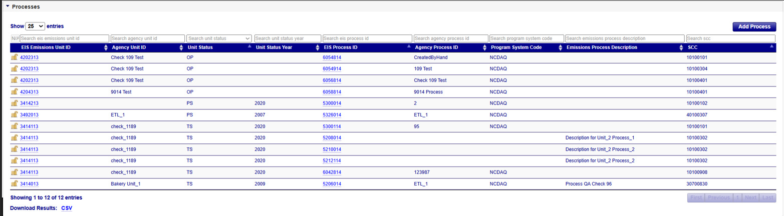
| Column Name | Description |
|---|---|
| EIS Emissions Unit ID | EIS Identifier for the unit as defined by the EIS System. |
| Agency Unit ID | An identifier by which an element is referred to by the responsible agency system. |
| Unit Status | Code that identifies the operating status of the emissions unit. |
| Status Year | Operating Status Year for the emissions unit. |
| EIS Process ID | EIS Identifier for the process as defined by the EIS System. Clicking on this id will display more details about the record. |
| Agency Process ID | An identifier by which an element is referred to by the responsible agency system. |
| Program System Code | The code that represents the information management system which has responsibility for the data in a linked or interrelated information management system. |
| Emissions Process Description | A text description of the emissions process. |
| SCC | EPA Source Classification Code that describes an emissions process. |
| Column Name | Description |
|---|---|
| EIS Control ID | EIS Identifier for the facility site control as defined by the EIS System. Clicking on this id will display more details about the record. |
| Agency Control ID | An identifier by which an element is referred to by the responsible agency system. |
| Program System Code | The code that represents the information management system which has responsibility for the data in a linked or interrelated information management system. |
| Control Measure Description | Describes the piece of equipment or practice that is used to reduce one or more pollutants. |
| Control Description | Description of the control device used at a facility |
| % Effectiveness | An estimate of portion of reporting period's activity which overall control sys (including both capture and control measures) were operating as designed (regardless of whether measure is due to rule or voluntary). |
| Control Status and Status Year | Code that identifies the operating status of the site control. / The first year in which the provided site control status code applies |
| Column Name | Description |
|---|---|
| EIS Path ID | EIS Identifier for the facility site path as defined by the EIS System. Clicking on this id will display more details about the record. |
| Agency Path ID | An identifier by which an element is referred to by the responsible agency system. |
| Program System Code | The code that represents the information management system which has responsibility for the data in a linked or interrelated information management system. |
| Path Name | Common name given for a facility site path. |
| Path Description | Description of a collection of control devices. |
| % Effectiveness | An estimate overall control system (including both capture and control measures) were operating as designed (regardless of whether measure is due to rule or voluntary). |
Facility Audit Log
Provides information about changes that have occurred to the information about the facility site. It provides time-stamped values of data at the facility site, who made the changes, and what organization that person belongs. Please see the Facility Site column listing if you need any descriptions of the fields presented.
Geographic Coordinate Audit Log
Provides information about changes that have occurred to the information about the coordinates for the facility site. It provides time-stamped values of data for the facility site coordinates, who made the changes, and what organization that person belongs. Please see the Geographic Coordinates column listing if you need any descriptions of the fields presented.
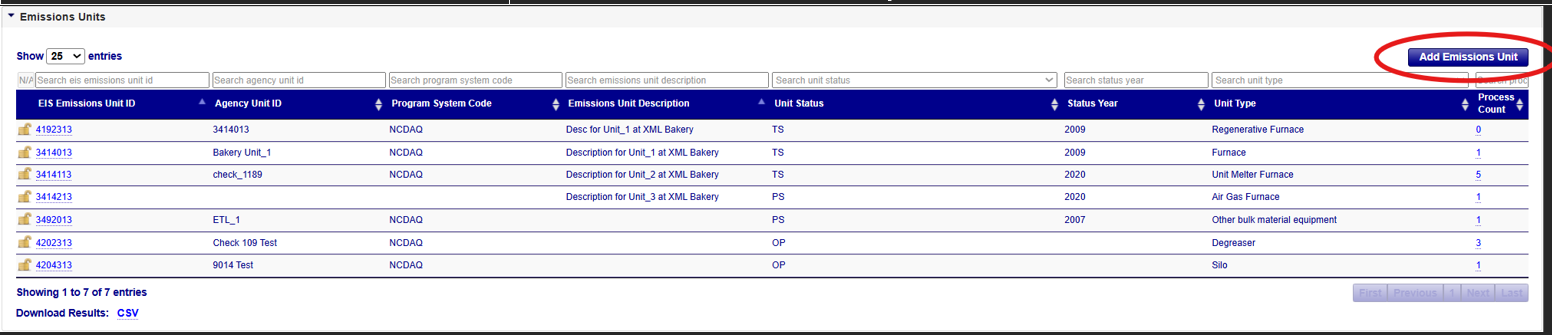
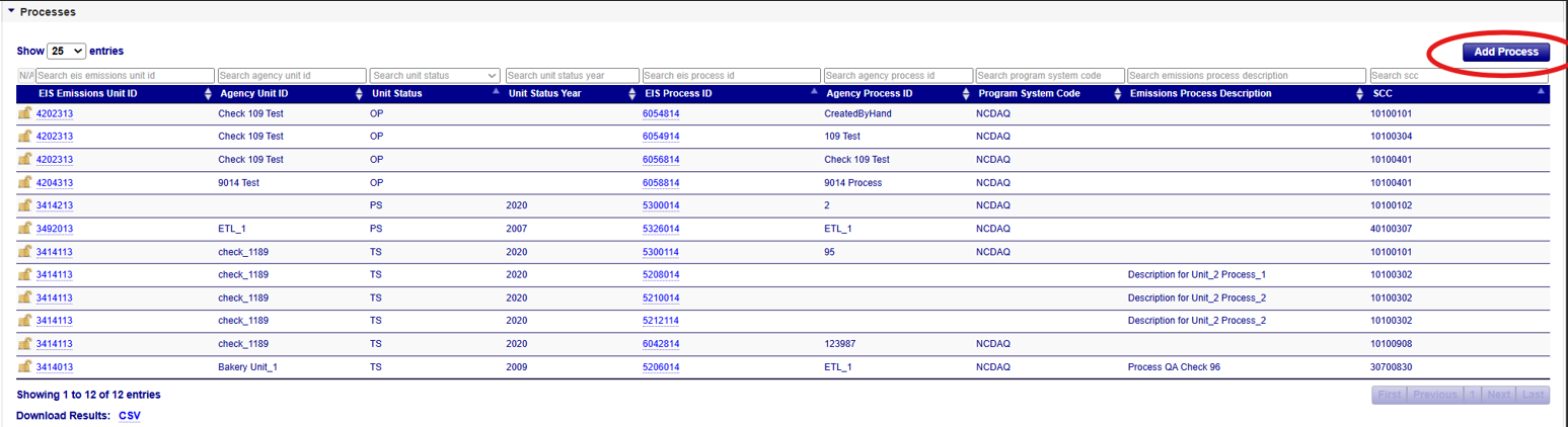
Adding Facility Site Records
If you have been authorized to update information for your agency and the facility inventory window is open, you will see additional links available in many areas of the application. The first will be in upper-right corner of the Facility Inventory and Point Emissions facility listing page.
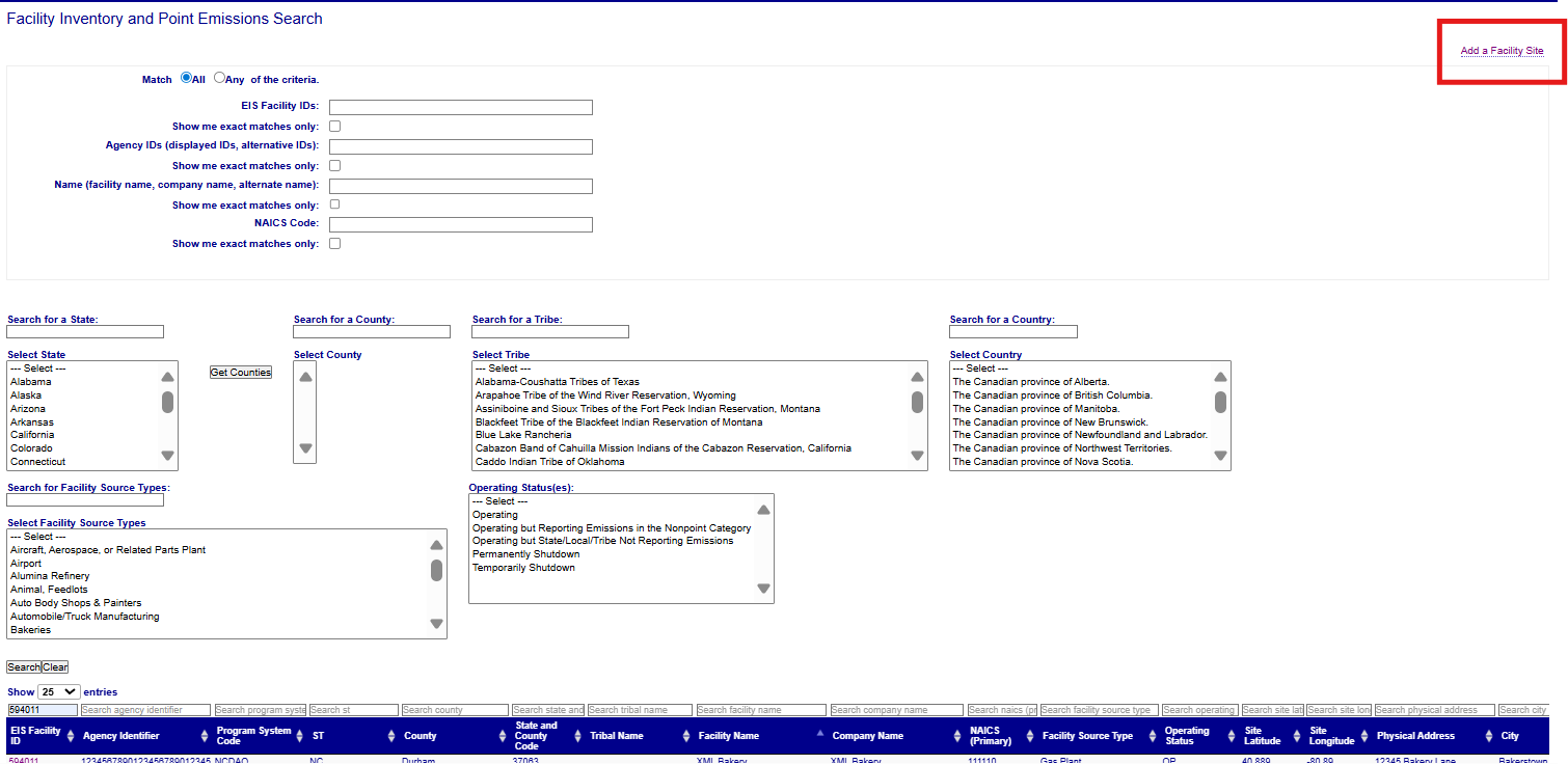
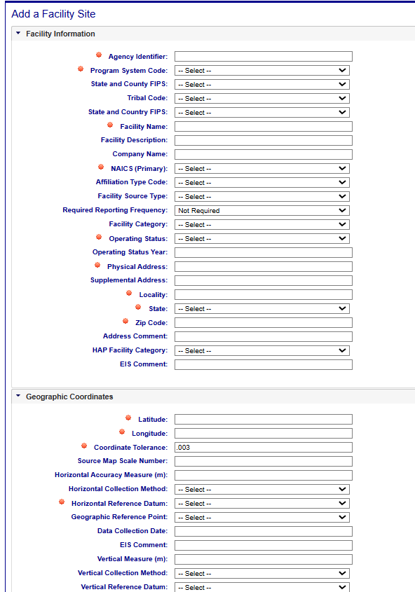
Clicking on this link will open a blank form that will allow you to create a new facility by populating the fields.
Editing Facility Site Records
If you have been authorized to update information for your agency and the facility inventory window is open, you will see additional links available in many areas of the application. Two of these links are on the right-hand side of the Facility Site details form:

Clicking on the “Edit Facility Site” link will open a form that will allow you to make changes to the information.
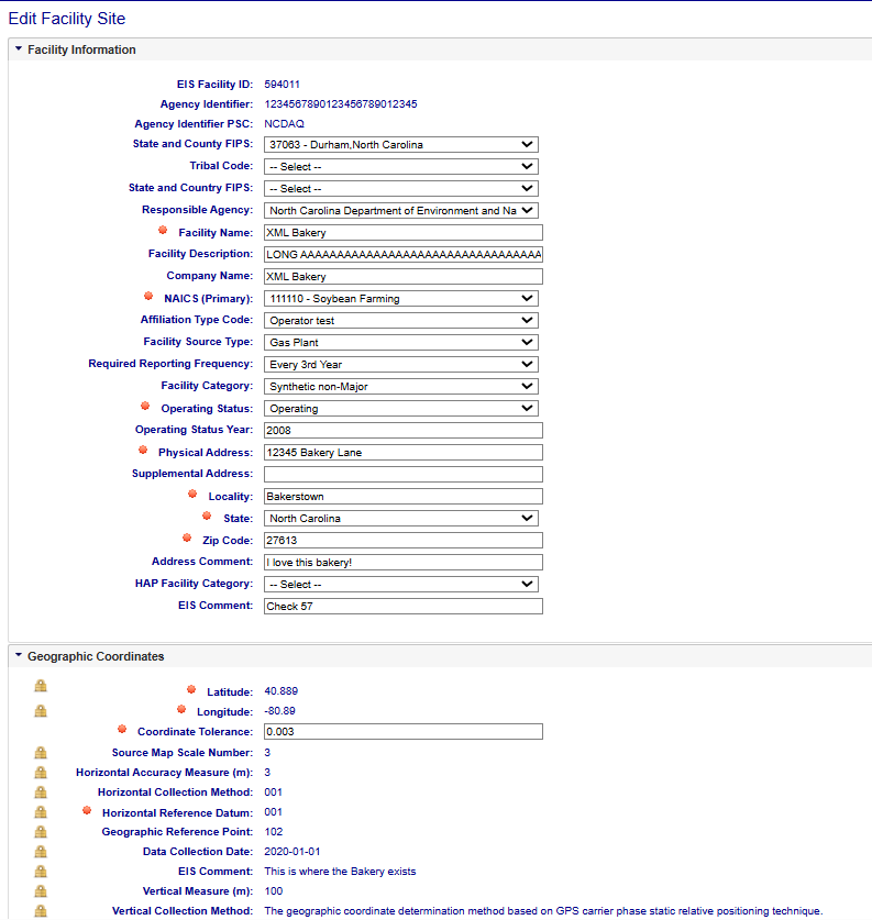
Please note that you do not have the ability to update all fields in the form. Only those values within text boxes or drop-down boxes may be edited. If you need to update one of the fields not in a text box (like the “Coordinate Tolerance” for example), you will need to contact an inventory developer at EPA.
Save, Undo, Cancel Buttons
Whether you are adding or editing records, the evaluation of the information is the same. The items with the red “starburst” indicator next to them are required fields. You will not be able to successfully save the information to the data base without these fields values. Once all necessary fields have been populated, click on the “Save” button at the bottom of the form. EIS will evaluate the information provided. If there are any issues, errors will be displayed at the top of the form.
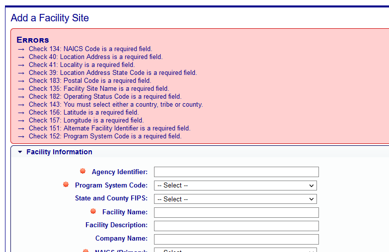
Clicking on the “Undo” button will clear the form of all entries and leave you on the “Add a Facility Site” page. Clicking on the “Cancel” button will not save any of the information that you have filled out, and you will be taken back to the Facility Listing page.